A few selected maps and one report, all relating in some way to the Pitt River Watershed.
Landscape units
Widgeon (PDF); Pitt (PDF); Alouette (PDF); Stave Lake area (PDF)
Legal Descriptions
Pitt to Harrison Lake (PDF); Harrison Lake to the Fraser River (PDF)
Historic Licensee operating areas ( Chilliwack Forestry District ) (PDF)
Lower Fraser Sustainable Resource Management Plan, SRMP (54 pages) 2013 (PDF)
Radio Channels being used up to 26 November 2015 (PDF)
Old Growth Managment in the Chilliwack Forestry District (PDF)
Squamish Foresty District
Squamish Operating tenures (PDF)
Old Growth Squamish Forestry District (PDF)
Squamish Forestry District Bridge Locations (PDF)
And a few images in a not so common format, from the Lands Office. Both are of the Upper Pitt River, and show some of the premptions. You will need to have one of the appropriate converters installed since they are both in MrSID format ( Download Screen ) PNWS02Tr07 and PNWS27Tr01
NOTE: If any of these links do not work, please email me, and I will host the documents elsewhere.
The links are all to the FTP sites of the Chilliwack and Squamish Forestry Districts
Monday, January 4, 2016
Friday, August 7, 2015
The "Legend" of Slumach
Will it never end? Sadly more folks will see this stuff and think that they can find it, and quickly find out that the area is fairly difficult to traverse in many places; should keep the local SAR community busy.
Shaw Cable Press release: Preview
The History Channel: Curse of the frozen gold
Slumach must be laughing in his grave, local Pitt River Lodge operator involved too.
And another who crashes helicopters and likes tall tales, with his friends who likes to spin stories of Nazi gold in the B-25 crash site
YES there is gold in the area, not much, but through very hard work you may make enough to buy yourself a meal. And the funny thing is it is not far from where Slumach actually lived, NOT far away up the lake.
All we need now is a legend of a giant lake monster, rub his belly and he grants you three wishes. :)
And please remember folks that the lake and river have claimed many lives through the years, and many times the bodies were never found; must be those damn giant lake monsters. AKA Sturgeon
Friday, August 8, 2014
Bridal Veil falls, AKA Defrauder falls
Bridal Veil falls is located where Defrauder Creek empties into Pitt Lake, for many generations, centuries, it was known as Bridal Veil falls; on July 3, 1963 the name of Defrauder Creek was officially applied, and was an established local name according to Geological Survey of Canada field staff. And then slowly Bridal Veil falls, became Defrauder Falls. Unknown where the name Defrauder came from, something to do with the logging or mining industry probably. The name of Bridal Falls is listed a few times in the geographical place names, but not for the local feature on Pitt Lake.
Some old and new pictures of the falls and a discussion can be found on the westcoastpaddler website
I came across an image of the Bridal Veil falls in this document: Summer handbook and official programme of the second annual British Colunmbia Conference Coast Summer School, including the Conference Epworth League and Sunday School Convention, held at Columbian Methodist College, New Westminster, B.C., commencing 2 p.m. July 3rd, including 10 p.m. July 8th, 1906 [microform] (1906)

Though it is of a poor quality, it matches the image on the postcard, below where the photograph is attributed to: New Westminster photographer W.T. Cooksley. with a view of three people at Bridal Veil Falls, Pitt Lake (circa 1905-1907)
 As you see this image is vastly superior, and we can now date this photo as ca. 1905-1906.


Washington Iron Works was a company in Seattle, Washington, founded by John M. Frink, (1855-1914) that built these steam skidders. The company was active from 1882 until the 1980s when its various divisions – manufacturing cranes, logging equipment, and presses – were gradually sold off. The Works closed in 1986.
Washington Iron Works engines revolutionized steam logging in the 1920s and 1930s.
Washington Iron Works built these machines in three sizes, 9x10¼, 10½x10¼ and
12x12. Demand for these yarders remained strong until about 1915 then fell off as more
sophisticated logging methods came into use. Washington built their last compound geared
yarder in July 1923 with only a handful sold in the previous five year.
The Pitt Lake unit is one of only six remaining, and should truly be in a museum.
A road leads up from where the donkey engine is and an old camp from the 1940-50's? is to be found above the falls, a small gypo sawmill is there, huge pile of waste, and collapsed buildings. There is also a crib dam in Defrauder Creek, filled with rubble, which was used to generate power at one time.
At one time there was also a cabin at the foot of the falls, and a relative of a friend of mine lived some of his last days there, until health concerns brought him out to "civilization" and shortly after the cabin was vandalized and burned, which sadly seems to be a typical fate for many buildings along Pitt Lake.
This area today is all inside Pinecone Burke Provincial Park, and continues to be popular with recreationists, as it has for many generations.
It has always been Bridal Veil Falls to me.
Some old and new pictures of the falls and a discussion can be found on the westcoastpaddler website
I came across an image of the Bridal Veil falls in this document: Summer handbook and official programme of the second annual British Colunmbia Conference Coast Summer School, including the Conference Epworth League and Sunday School Convention, held at Columbian Methodist College, New Westminster, B.C., commencing 2 p.m. July 3rd, including 10 p.m. July 8th, 1906 [microform] (1906)
Though it is of a poor quality, it matches the image on the postcard, below where the photograph is attributed to: New Westminster photographer W.T. Cooksley. with a view of three people at Bridal Veil Falls, Pitt Lake (circa 1905-1907)
1942 map
1988 map
photo by: Richard Teszka 2007
Abandoned on the west shore of Pitt Lake just north of Defrauder Creek.
This is a logging donkey relic from the logging of TB 290, it was built by the Washington Iron Works, Seattle, Washington C/N 1502 and is a 2 drum [duplex] yarding setup. It was originally further up onshore, but a tugboat company in New Westminster attempted to recover the unit, and gave up after pulling it along the shore, and the log skids crumbled, and it was caught up in the rocks.Washington Iron Works was a company in Seattle, Washington, founded by John M. Frink, (1855-1914) that built these steam skidders. The company was active from 1882 until the 1980s when its various divisions – manufacturing cranes, logging equipment, and presses – were gradually sold off. The Works closed in 1986.
Washington Iron Works engines revolutionized steam logging in the 1920s and 1930s.
Washington Iron Works built these machines in three sizes, 9x10¼, 10½x10¼ and
12x12. Demand for these yarders remained strong until about 1915 then fell off as more
sophisticated logging methods came into use. Washington built their last compound geared
yarder in July 1923 with only a handful sold in the previous five year.
The Pitt Lake unit is one of only six remaining, and should truly be in a museum.
A road leads up from where the donkey engine is and an old camp from the 1940-50's? is to be found above the falls, a small gypo sawmill is there, huge pile of waste, and collapsed buildings. There is also a crib dam in Defrauder Creek, filled with rubble, which was used to generate power at one time.
At one time there was also a cabin at the foot of the falls, and a relative of a friend of mine lived some of his last days there, until health concerns brought him out to "civilization" and shortly after the cabin was vandalized and burned, which sadly seems to be a typical fate for many buildings along Pitt Lake.
This area today is all inside Pinecone Burke Provincial Park, and continues to be popular with recreationists, as it has for many generations.
It has always been Bridal Veil Falls to me.
Tuesday, January 28, 2014
Helicopter accident
More common the past few years to have aviation accidents in the Pitt Watershed than marine accidents, very telling about the quality of training of aviators. Overdue for fatalities; the clock is ticking.....
Helicopter rolls onto riverbank, sinks at Pitt Lake; pilot, passenger okay.
Two taken to Abbotsford Hospital after Pitt Lake crash ( video, but not of crash site )
I will add to this as more information becomes available.
it was a Schweizer 269 helicopter, looks like a RC chopper on steroids !
Helicopter rolls onto riverbank, sinks at Pitt Lake; pilot, passenger okay.
Two taken to Abbotsford Hospital after Pitt Lake crash ( video, but not of crash site )
I will add to this as more information becomes available.
it was a Schweizer 269 helicopter, looks like a RC chopper on steroids !
Wednesday, December 25, 2013
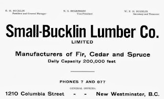
Small & Bucklin
Small and Bucklin was a large logging, sawmilling outfit from the U.S.A., that at one time also had extensive timber lands along Pitt Lake, and also in the Upper Pitt River. They had a sawmill in New Westminster, among other activities elsewhere.
In my researches into the Pitt Watershed it is unavoidable not to come across information about their activities, sadly only the negative things were reported in the newspapers, and they were frequent.
Recently I came across an article from 1911, here it is:
 Transcribed here:
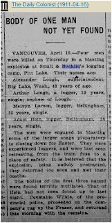
16 April 1911 The Daily Colonist,(Victoria)
Vancouver, April 15.―Four men were killed on Thursday in a blasting explosion at Small & Bucklin's logging camp, Pitt Lake. Their names are:
Alexander Lough, superintendent, Big Lake, Washington, 43 years of age.
Arthur Lough, a logger, 19 years, single, nephew of Lough.
Melvyn Larsen, logger, Bellingham, 35 years, single.
Adam Hein, logger, Bellingham, 35 years, single.
The men were engaged in blasting some of the larger snags preparatory to closing down for Easter. They were experienced loggers, and were last seen retreating from the train fuse to a place of safety. It is believed that the explosion, being unduly protracted, they returned too soon and met their deaths.
The bodies of the first three named were found horribly mutilated. That of Hein had not been found up to last night. Constable Wilkie, of the Provincial police, proceeded on the company's tug up the Fraser, and returned this morning with the remains.
The strangest thing about this event is the fact that even though the police were involved, none of the deaths were registered in British Columbia ! I frequently run across this problem, but never on this scale with four dead men.
The Phoenix Pioneer, January 4, 1913
Due in great measure to the evidence that was given, at the recent trials for perjury in New Westminster, the management, of the Small & Bucklin lumber mills in the Royal City have decided to dismiss every Hindu in their employment and to replace them with white labor. This decision was arrived at only after long and careful consideration of the circumstances in connection with the charges.
It will effect about ninety Hindus, who resided in shacks, the property of the company. in order to make the decision all the more effective, the demolition of the shacks was commenced at once and the majority of them razed to the ground by fire.
ln the course of the evidence at the recent trials it was alleged that, in order to retain their jobs, the Hindus had been in the habit of giving bribes to certain officials, and the management were influenced in the step they have taken by this fact.
October 17, 1913
C.A. Woods and W.B. Vaughan were accidently drowned while booming logs for the Small and Bucklin Lumber Co., at Pitt River. Also not registered at BC Archives.
and on, and on...


possibly Poplar Island on the right.
BOTTOM: Small & Bucklin sawmill, at the western end of New Westminster.


In my researches into the Pitt Watershed it is unavoidable not to come across information about their activities, sadly only the negative things were reported in the newspapers, and they were frequent.
Recently I came across an article from 1911, here it is:

16 April 1911 The Daily Colonist,(Victoria)
BODY OF ONE MAN NOT YET FOUND
Vancouver, April 15.―Four men were killed on Thursday in a blasting explosion at Small & Bucklin's logging camp, Pitt Lake. Their names are:
Alexander Lough, superintendent, Big Lake, Washington, 43 years of age.
Arthur Lough, a logger, 19 years, single, nephew of Lough.
Melvyn Larsen, logger, Bellingham, 35 years, single.
Adam Hein, logger, Bellingham, 35 years, single.
The men were engaged in blasting some of the larger snags preparatory to closing down for Easter. They were experienced loggers, and were last seen retreating from the train fuse to a place of safety. It is believed that the explosion, being unduly protracted, they returned too soon and met their deaths.
The bodies of the first three named were found horribly mutilated. That of Hein had not been found up to last night. Constable Wilkie, of the Provincial police, proceeded on the company's tug up the Fraser, and returned this morning with the remains.
The strangest thing about this event is the fact that even though the police were involved, none of the deaths were registered in British Columbia ! I frequently run across this problem, but never on this scale with four dead men.
---o---
The Phoenix Pioneer, January 4, 1913
Bounced the Hindus
Due in great measure to the evidence that was given, at the recent trials for perjury in New Westminster, the management, of the Small & Bucklin lumber mills in the Royal City have decided to dismiss every Hindu in their employment and to replace them with white labor. This decision was arrived at only after long and careful consideration of the circumstances in connection with the charges.
It will effect about ninety Hindus, who resided in shacks, the property of the company. in order to make the decision all the more effective, the demolition of the shacks was commenced at once and the majority of them razed to the ground by fire.
ln the course of the evidence at the recent trials it was alleged that, in order to retain their jobs, the Hindus had been in the habit of giving bribes to certain officials, and the management were influenced in the step they have taken by this fact.
---0---
October 17, 1913
C.A. Woods and W.B. Vaughan were accidently drowned while booming logs for the Small and Bucklin Lumber Co., at Pitt River. Also not registered at BC Archives.
and on, and on...

AD from 1914 in the Henderson Directory

AD from 1908
This is just a little taste of what I have about the Company and its history. And Yes, Bucklin Creek, in the Upper Pitt River is named after Edgar H. Bucklin. In their operations in the Pitt watershed I have lost count of how many died getting the wood to the mill, must be over twenty.

Small & Bucklin sawmill with stacks of lumber, buildings. ca. 1920.
New Westminster Archives IHP0958
The sawmill was located at 1210 Columbia Street, New Westminster. Today in 2013 it is all residentialNew Westminster Archives IHP0958

Two Fraser River views. VPL 6892. date: 1910, photo: Philip Timms.
TOP: Probably looking west along the Fraser, unknown buildings on the left, possibly Poplar Island on the right.
BOTTOM: Small & Bucklin sawmill, at the western end of New Westminster.

View of New Westminster, looking towards Lulu Island.
VPL 13735 date: ca.1912, photo R. Broadbridge.
VPL 13735 date: ca.1912, photo R. Broadbridge.

View of Bucklin Lumber Co. Ltd.
VPL 11381 date:1921, photo: Leonard Frank.
VPL 11381 date:1921, photo: Leonard Frank.
Friday, August 23, 2013
Burke and Widgeon a hiker's guide
A local hiker Lyle Litzenberger has recently published a book primarily focused on the trails in the Burke Ridge( Mountain) and Widgeon Creek areas.
Newspaper article: Burke, by the book
Burke and Widgeon a hiker's guide
Lyle Litzenberger
pebblestone publishing 2013
ISBN 0981125808, 9780981125800
And a dedicated website for the book: BurkeandWidgeon
Buy the book information
Long overdue, I hope that this book is widely read and enjoyed.
Newspaper article: Burke, by the book
Burke and Widgeon a hiker's guide
Lyle Litzenberger
pebblestone publishing 2013
ISBN 0981125808, 9780981125800
And a dedicated website for the book: BurkeandWidgeon
Buy the book information
Long overdue, I hope that this book is widely read and enjoyed.
Thursday, May 2, 2013
Pictographs
These photos were taken many years ago, (mid 1980's) no idea how these pictographs have fared in the meantime. They are up on the western side of the lake about mid way.
Please look at, but do not touch or alter these important pictographs in any way.


There are more than these photos show. Scanned from negatives.
Please look at, but do not touch or alter these important pictographs in any way.

Pitt Lake aliens!!!


This image appears to be two people in a canoe, with one standing and pointing a rifle?

General view of the most visible pictographs from the lake.
There are more than these photos show. Scanned from negatives.
Pitt
Lake known pictograph sites
DiRp 9.
At Deer Point on the eastern shore of Pitt Lake. Lundy 1972.
DiRp 8.
On the western shore of Pitt Lake about 1/6th mile south of Cedar Point. Lundy
1972.
DiRp 7.
Midway between Cedar Point and Bridal Veil Falls on the western shore of the
lake. Lundy 1972.
DiRp 10.
On the western shore of Pitt Lake near Cedar Point about 150 feet south of site
DiRp 7. Lundy/Oliver survey 1972.
DiRp 11.
On the western shore of Pitt Lake about 100 feet north of site DiRp 1. Lundy/Oliver
survey 1972.
DiRp 1.
On the western shore of Pitt Lake, opposite the northern end of Little Goose
Island, and just south of Bridal Veil Falls. Jennes 1935, Lundy 1972.
DiRp 6.
On the western shore of Pitt Lake, opposite the northern end of Little Goose
Island and just north of site DiRp 5. Lundy 1972.
DiRp 5.
On the western shore of Pitt Lake, opposite the northern end of Little Goose
Island and just south of Bridal Veil Falls. Lundy 1972.
DiRp 12.
On the western shore of Pitt Lake, about 500 meters north of site DiRp 4 and
directly opposite the mouth of Raven Creek. Lundy/Oliver survey 1972.
DiRp 13.
On the eastern shore of Pitt Lake about 600 meters north of the outfall of
Raven Creek, Lundy 1972.
DiRp 4.
On the western shore of Pitt Lake south of Goose Island and opposite the mouth
of Raven Creek. Lundy 1972.
The listings above are from the 1974 M.A. dissertion of Doris Marion Lundy, in her report:
Rock art of the Northwest Coast ( PDF )
The listings above are from the 1974 M.A. dissertion of Doris Marion Lundy, in her report:
Rock art of the Northwest Coast ( PDF )
Subscribe to:
Posts (Atom)