More common the past few years to have aviation accidents in the Pitt Watershed than marine accidents, very telling about the quality of training of aviators. Overdue for fatalities; the clock is ticking.....
Helicopter rolls onto riverbank, sinks at Pitt Lake; pilot, passenger okay.
Two taken to Abbotsford Hospital after Pitt Lake crash ( video, but not of crash site )
I will add to this as more information becomes available.
it was a Schweizer 269 helicopter, looks like a RC chopper on steroids !
Tuesday, January 28, 2014
Wednesday, December 25, 2013
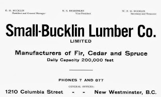
Small & Bucklin
Small and Bucklin was a large logging, sawmilling outfit from the U.S.A., that at one time also had extensive timber lands along Pitt Lake, and also in the Upper Pitt River. They had a sawmill in New Westminster, among other activities elsewhere.
In my researches into the Pitt Watershed it is unavoidable not to come across information about their activities, sadly only the negative things were reported in the newspapers, and they were frequent.
Recently I came across an article from 1911, here it is:
 Transcribed here:
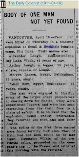
16 April 1911 The Daily Colonist,(Victoria)
Vancouver, April 15.―Four men were killed on Thursday in a blasting explosion at Small & Bucklin's logging camp, Pitt Lake. Their names are:
Alexander Lough, superintendent, Big Lake, Washington, 43 years of age.
Arthur Lough, a logger, 19 years, single, nephew of Lough.
Melvyn Larsen, logger, Bellingham, 35 years, single.
Adam Hein, logger, Bellingham, 35 years, single.
The men were engaged in blasting some of the larger snags preparatory to closing down for Easter. They were experienced loggers, and were last seen retreating from the train fuse to a place of safety. It is believed that the explosion, being unduly protracted, they returned too soon and met their deaths.
The bodies of the first three named were found horribly mutilated. That of Hein had not been found up to last night. Constable Wilkie, of the Provincial police, proceeded on the company's tug up the Fraser, and returned this morning with the remains.
The strangest thing about this event is the fact that even though the police were involved, none of the deaths were registered in British Columbia ! I frequently run across this problem, but never on this scale with four dead men.
The Phoenix Pioneer, January 4, 1913
Due in great measure to the evidence that was given, at the recent trials for perjury in New Westminster, the management, of the Small & Bucklin lumber mills in the Royal City have decided to dismiss every Hindu in their employment and to replace them with white labor. This decision was arrived at only after long and careful consideration of the circumstances in connection with the charges.
It will effect about ninety Hindus, who resided in shacks, the property of the company. in order to make the decision all the more effective, the demolition of the shacks was commenced at once and the majority of them razed to the ground by fire.
ln the course of the evidence at the recent trials it was alleged that, in order to retain their jobs, the Hindus had been in the habit of giving bribes to certain officials, and the management were influenced in the step they have taken by this fact.
October 17, 1913
C.A. Woods and W.B. Vaughan were accidently drowned while booming logs for the Small and Bucklin Lumber Co., at Pitt River. Also not registered at BC Archives.
and on, and on...


possibly Poplar Island on the right.
BOTTOM: Small & Bucklin sawmill, at the western end of New Westminster.


In my researches into the Pitt Watershed it is unavoidable not to come across information about their activities, sadly only the negative things were reported in the newspapers, and they were frequent.
Recently I came across an article from 1911, here it is:

16 April 1911 The Daily Colonist,(Victoria)
BODY OF ONE MAN NOT YET FOUND
Vancouver, April 15.―Four men were killed on Thursday in a blasting explosion at Small & Bucklin's logging camp, Pitt Lake. Their names are:
Alexander Lough, superintendent, Big Lake, Washington, 43 years of age.
Arthur Lough, a logger, 19 years, single, nephew of Lough.
Melvyn Larsen, logger, Bellingham, 35 years, single.
Adam Hein, logger, Bellingham, 35 years, single.
The men were engaged in blasting some of the larger snags preparatory to closing down for Easter. They were experienced loggers, and were last seen retreating from the train fuse to a place of safety. It is believed that the explosion, being unduly protracted, they returned too soon and met their deaths.
The bodies of the first three named were found horribly mutilated. That of Hein had not been found up to last night. Constable Wilkie, of the Provincial police, proceeded on the company's tug up the Fraser, and returned this morning with the remains.
The strangest thing about this event is the fact that even though the police were involved, none of the deaths were registered in British Columbia ! I frequently run across this problem, but never on this scale with four dead men.
---o---
The Phoenix Pioneer, January 4, 1913
Bounced the Hindus
Due in great measure to the evidence that was given, at the recent trials for perjury in New Westminster, the management, of the Small & Bucklin lumber mills in the Royal City have decided to dismiss every Hindu in their employment and to replace them with white labor. This decision was arrived at only after long and careful consideration of the circumstances in connection with the charges.
It will effect about ninety Hindus, who resided in shacks, the property of the company. in order to make the decision all the more effective, the demolition of the shacks was commenced at once and the majority of them razed to the ground by fire.
ln the course of the evidence at the recent trials it was alleged that, in order to retain their jobs, the Hindus had been in the habit of giving bribes to certain officials, and the management were influenced in the step they have taken by this fact.
---0---
October 17, 1913
C.A. Woods and W.B. Vaughan were accidently drowned while booming logs for the Small and Bucklin Lumber Co., at Pitt River. Also not registered at BC Archives.
and on, and on...

AD from 1914 in the Henderson Directory

AD from 1908
This is just a little taste of what I have about the Company and its history. And Yes, Bucklin Creek, in the Upper Pitt River is named after Edgar H. Bucklin. In their operations in the Pitt watershed I have lost count of how many died getting the wood to the mill, must be over twenty.

Small & Bucklin sawmill with stacks of lumber, buildings. ca. 1920.
New Westminster Archives IHP0958
The sawmill was located at 1210 Columbia Street, New Westminster. Today in 2013 it is all residentialNew Westminster Archives IHP0958

Two Fraser River views. VPL 6892. date: 1910, photo: Philip Timms.
TOP: Probably looking west along the Fraser, unknown buildings on the left, possibly Poplar Island on the right.
BOTTOM: Small & Bucklin sawmill, at the western end of New Westminster.

View of New Westminster, looking towards Lulu Island.
VPL 13735 date: ca.1912, photo R. Broadbridge.
VPL 13735 date: ca.1912, photo R. Broadbridge.

View of Bucklin Lumber Co. Ltd.
VPL 11381 date:1921, photo: Leonard Frank.
VPL 11381 date:1921, photo: Leonard Frank.
Friday, August 23, 2013
Burke and Widgeon a hiker's guide
A local hiker Lyle Litzenberger has recently published a book primarily focused on the trails in the Burke Ridge( Mountain) and Widgeon Creek areas.
Newspaper article: Burke, by the book
Burke and Widgeon a hiker's guide
Lyle Litzenberger
pebblestone publishing 2013
ISBN 0981125808, 9780981125800
And a dedicated website for the book: BurkeandWidgeon
Buy the book information
Long overdue, I hope that this book is widely read and enjoyed.
Newspaper article: Burke, by the book
Burke and Widgeon a hiker's guide
Lyle Litzenberger
pebblestone publishing 2013
ISBN 0981125808, 9780981125800
And a dedicated website for the book: BurkeandWidgeon
Buy the book information
Long overdue, I hope that this book is widely read and enjoyed.
Thursday, May 2, 2013
Pictographs
These photos were taken many years ago, (mid 1980's) no idea how these pictographs have fared in the meantime. They are up on the western side of the lake about mid way.
Please look at, but do not touch or alter these important pictographs in any way.


There are more than these photos show. Scanned from negatives.
Please look at, but do not touch or alter these important pictographs in any way.

Pitt Lake aliens!!!


This image appears to be two people in a canoe, with one standing and pointing a rifle?

General view of the most visible pictographs from the lake.
There are more than these photos show. Scanned from negatives.
Pitt
Lake known pictograph sites
DiRp 9.
At Deer Point on the eastern shore of Pitt Lake. Lundy 1972.
DiRp 8.
On the western shore of Pitt Lake about 1/6th mile south of Cedar Point. Lundy
1972.
DiRp 7.
Midway between Cedar Point and Bridal Veil Falls on the western shore of the
lake. Lundy 1972.
DiRp 10.
On the western shore of Pitt Lake near Cedar Point about 150 feet south of site
DiRp 7. Lundy/Oliver survey 1972.
DiRp 11.
On the western shore of Pitt Lake about 100 feet north of site DiRp 1. Lundy/Oliver
survey 1972.
DiRp 1.
On the western shore of Pitt Lake, opposite the northern end of Little Goose
Island, and just south of Bridal Veil Falls. Jennes 1935, Lundy 1972.
DiRp 6.
On the western shore of Pitt Lake, opposite the northern end of Little Goose
Island and just north of site DiRp 5. Lundy 1972.
DiRp 5.
On the western shore of Pitt Lake, opposite the northern end of Little Goose
Island and just south of Bridal Veil Falls. Lundy 1972.
DiRp 12.
On the western shore of Pitt Lake, about 500 meters north of site DiRp 4 and
directly opposite the mouth of Raven Creek. Lundy/Oliver survey 1972.
DiRp 13.
On the eastern shore of Pitt Lake about 600 meters north of the outfall of
Raven Creek, Lundy 1972.
DiRp 4.
On the western shore of Pitt Lake south of Goose Island and opposite the mouth
of Raven Creek. Lundy 1972.
The listings above are from the 1974 M.A. dissertion of Doris Marion Lundy, in her report:
Rock art of the Northwest Coast ( PDF )
The listings above are from the 1974 M.A. dissertion of Doris Marion Lundy, in her report:
Rock art of the Northwest Coast ( PDF )
Tuesday, October 16, 2012
Cessna 172 crash
On Monday the 15th of October, a Cessna 172 crashed into Pitt Lake, with the loss of one of the two occupants.
One man dead, another hospitalized after float plane crashes into Pitt Lake
Flight instructor was victim of Pitt Lake float-plane crash,
Student released from hospital after escaping from wreckage
The Pitt Lake area is frequently used by flight schools, pilots for training purposes, and every few years an accident occurs.
R.I.P.
Sunday, December 4, 2011
Mitchell B-25 crash in 1953
Two photos from the 1953 B-25 crash just north of Widgeon Lake, at the top of a mountain.
 Frank Goodship fonds. Item No. IHP9267-0710. Date 1953. b&w negative ; 6 x 6 cm. Shows the remains of a Royal Canadian Air Force plane crashed against a mountain. Research indicates it was a Mitchell B-25 Mk 3PT Ex USAF B-25J-30/32-NC serial number 44-31346 that crashed at Widgeon Lake, near Pitt Lake. Record ID 48255

Frank Goodship fonds. Item No. IHP9267-0712. Date 1953. b&w negative ; 6 x 6 cm. Photograph of a Royal Canadian Air Force plane crashed against a mountain with helicopter 9606 hovering over it. Research indicates it was a Mitchell B-25 Mk 3PT Ex USAF B-25J-30/32-NC serial number 44-31346 that crashed at Widgeon Lake, near Pitt Lake. Record ID 48257
Both photos from the New Westminster Archives
I have created a PDF file that contains pictures and newspaper articles from the time of the accident.
Download the 1130kb PDF, or view it using the Google viewer in Google docs. (No sign in needed)
Combat Report (1942)
Documentary short, nominated for an Oscar in 1943. Follows the crew of a Mitchell bomber from the 2nd Bombardment Group as they fight submarines. Signal Corps Film No 2.
And if you could find one to fly, you had better study this:
Pilot Training Manual For The Mitchell Bomber B-25 (1944)
Nice video..How to Fly the B-25 Mitchell Bomber 1944 USAAF Training Film
A Panoramio user: fitafter4kids has posted some nice aerial photos of the crash site, the best yet :)
Please remember that this is a protected site, and Nothing is to be removed.
Five people lost their lives here: Ernest Dorph Thygesen, Jack Wayne McIntosh, Murray Donald Hill, Kirk Gerald McGinnis, and, Ian Martin De Witt.
Cheers
Sunday, October 30, 2011
Grant Narrows
From the Georgia Strait; In the Grant Narrows wilds, it's another world
Time will tell how the new ownership goes.
Time will tell how the new ownership goes.
Subscribe to:
Posts (Atom)